In 2001/2,
Project for Public Spaces (PPS), a non-profit founded in 1975 to improve the design and management of parks and other public spaces in the United States, produced a fairly detailed
comprehensive master plan for Baltimore’s Mount Vernon Place. The report went well beyond suggesting ways of improving accessibility (which, incidentally, it addresses masterfully) to incorporate suggestions for improving pedestrian access and safety, for calming traffic in and around Mount Vernon Place, and for increasing vitality around the monument while at the same time reducing wear and tear on the plantings and the park infrastructure. This report included action items for short- and long-term improvements, as well as annotated, detailed ground plans of what Mount Vernon Place might look like were the suggestions implemented. The report called for greater coordination among the city’s Planning, Transportation, and Recreation & Parks departments and the creation of a public-private partnership to oversee the implementation of the plan. Sadly, few, if any, of PPS’s recommendations were incorporated into the Recreation & Parks Department’s proposed plan for the parks.

I mention this master plan because, contrary to what has been reported in that innacurate and inflammatory
Baltimore Sun article last December, viable alternatives to Rec & Parks' ill-conceived plan for Mount Vernon Place do, in fact, exist and have for some time. In fact, the
PPS plan addresses accessibility in the same way as the newly redesigned War Memorial Plaza in front of City Hall. In brief,
the PPS plan is a bona fide planning document that takes the long view: It considers issues relating to accessibility, pedestrian safety and movement, traffic circulation and calming, mass transit, programming and public events, and the perennial problem of maintenance.
Details of the PPS Plan (and why it's better)
The PPS plan for Mount Vernon Place is really quite simple. It says: Research what you have so you understand how to move forward, and then coordinate with other groups and city agencies to achieve the best solution. Rec & Parks didn’t want to do either: Didn’t want to work with Planning, didn’t want to work with Transportation, didn’t want to spend the time or the money to research the history of the site.
The PPS report does or recommends lots of great things:
1. The report improves accessibility AND respects the Carrere & Hastings design. Although PPS did not research the history of the current design in depth, the team seemed to know enough about Carrere & Hastings to know that the design was important and worth preserving. The report takes an
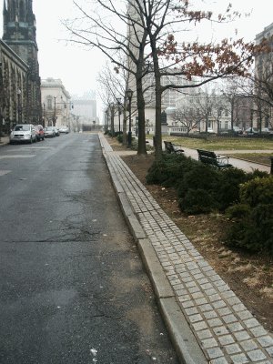
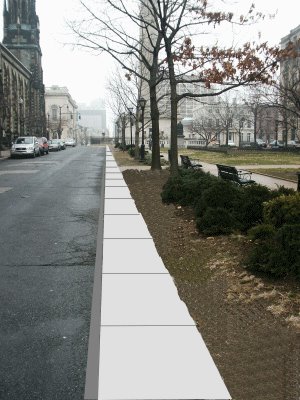
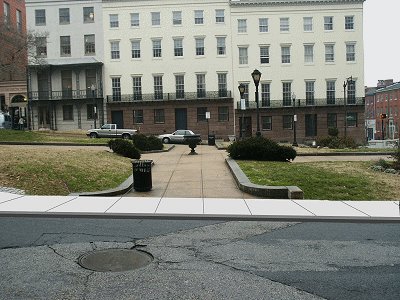
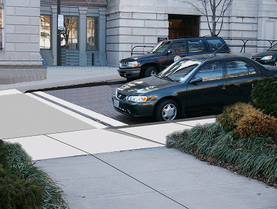
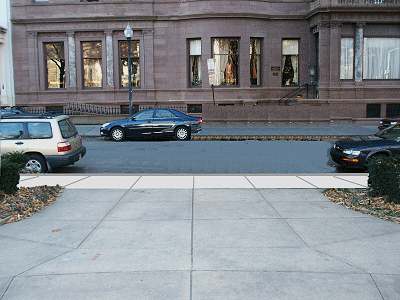
additive approach to the four squares as opposed to a subtractive approach (the report doesn’t take away anything from the historic design, in other words). The accessibility and other recommendations all pretty much take place outside the individual squares themselves (Carrere & Hastings called them squares; most people today call them parks). The most significant (and, in my opinion, exciting) of these is the creation of perimeter sidewalks along the outsides of the squares (taken out of the roadbed), which not only create points of access at the midpoints of the parks but also serve to calm traffic and cut down on the wear and tear to the plantings and infrastructure. By adding a new circulation layer around the parks, the PPS plan is able to improve accessibility AND preserve the historic design.
2. The report goes well beyond improving accessibility and addresses the issues of pedestrian safety and traffic calming, which are of supreme importance to everyone regardless of their condition. For instance, the PPS plan recommends different paving materials and patterns for all crosswalks. The problem with the Rec & Parks plan is that it addresses
nothing outside the squares themselves. So, in the end, how much safer or accessible are they if people (on foot or in wheelchairs) have to negotiate the traffic and peer out beyond parked cars just to cross the street? The accessibility solution recommended by PPS is basically the same as the one recently employed at War Memorial Plaza—circulation along the perimeter with access at the midpoint.
3. The report calls for greater coordination among city agencies. The table on page 15 identifies the Planning Department as the appropriate agency for supervising the creation and execution of the master plan and for acting as liaison for other city agencies (including Rec & Parks). Although the report suggests that Rec & Parks have final approval over all physical changes, it suggests that Rec & Parks participate in, not guide or direct, the master planning process. Of course, the tragedy of it all is that the city's
Commission for Historical & Architectural Preservation (CHAP) is not mentioned; nor is it mentioned that Mount Vernon Place is a
National Historic Landmark. The report also assigns responsibilities to Rec & Parks that are rightfully CHAP’s (but, that likely has to do with them not knowing about the national and local designations). However, CHAP’s move into Planning has basically made that omission a non-issue.
4. The report also addresses programming, use, maintenance, etc., and calls for the creation of a viable public-private partnership for implementing the plan. Judging from the amazing success the planners of the neighborhood’s children’s park have had in raising about 500K for that project, I just don’t see fundraising ever becoming a problem, esp. since all of Maryland seems to revere of Mount Vernon Place as its own.
If you want to see for yourself how the PPS plan compares with the Rec & Parks plan, take a look at this detailed
plan comparison.

Case Study #1: How did THIS happen?
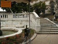
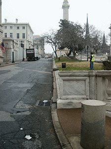
A car (or truck) traveling north at a high rate of speed into Mount Vernon Place clipped the western edge of the balustrade along the southern edge of the South Square--for most people the official entrance into Mount Vernon Place.
How do the two plans for Mount Vernon Place propose to prevent this costly and destructive incident from happening again in the future?Project for Public Spaces1. Use dramatic plantings at the south end to remind drivers that this is not an area for speeding, and
2. install perimeter sidewalk around South Square that would serve as a traffic calmer and buffer (and also improve accessibility!)
Rec & ParksPlan does nothing either to prevent or reduce the likelihood of future automobile-related damage or destruction to the marble balustrades of the South or any of the other three squares of Mount Vernon Place...

Case Study #2: How did THIS happen?
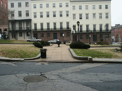
Just days before the Baltimore Book Festival, the Department of Transportation installed this enormously inappropriate traffic signal box in the North Square without seeking the prior approval of either the Planning Department, CHAP, Rec & Parks, Mount Vernon Cultural District, the Mount Vernon Belvidere Association, or the Friends.
How do the two plans for Mount Vernon Place propose to prevent this costly and destructive incident from happening again in the future?Project for Public Spaces1. Create a real conservancy and public-private partnership for the long-term use and preservation of Mount Vernon Place, and
2. Establish the Planning Department as liaison between conservancy and all city agencies
Rec & ParksPlan does nothing to improve inter-agency coordination or to establish a single management authority to oversee the use, preservation, and maintenance of Mount Vernon Place...


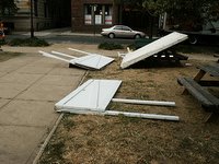
 Pictures taken after the Baltimore Book Festival and other events in Mount Vernon Place tell the real story. No one seems to care about the damage to the marbles, trees, and other plantings caused by the huge crowds drawn to this small public space or by the ground crews responsible for stringing up electrical wires, erecting stages and booths, or hauling in picnic tables and funnel cake carts. The city government, the Baltimore Office of Promotion & the Arts (BOPA), the vendors, and the various other event sponsors treat Mount Vernon Place like it's the Baltimore City Fairgrounds. They set up shop, make money, and leave, and Mount Vernon Place suffers.
 BOPA runs roughshod over the four squares of Mount Vernon Place when it sets up for Baltimore Book Festival each September. Yet, BOPA seldom, if ever, pays for the damage caused by this event. The acting director of the Baltimore City Department of Recreation Parks, Connie Brown, told area residents at a fall general meeting of the
  Where were the Rec & Parks people when the crews were putting things up and tearing things down for Flower Mart or the book festival? Did the Friends of Mount Vernon Place (FMVP) have anyone on hand to supervise the crews and make sure they didn't cast fences into the flowerbeds? How can BOPA get away with this year after year without paying its fair share of the maintenance and repair costs? You'd think we were dealing with a bunch of 12 year-olds since no one wants to claim responsibility for making sure that BOPA and other organizations that sponsor events in the squares leave Mount Vernon Place in a better condition than when they found it...